Share the page
Preservation of Lake Chad: contribution to the Lake development strategy
Project
This project is carried out with the support of the European Union.


-
Project start date
-
Status
Completed
-
Estimated date of project termination
-
-
Project financing date
-
-
Financing duration
-
3 ans
-
Type of program
-
FFEM
-
Global financing amount
-
€ 12400000
-
FFEM financing amount
-
€ 800000
-
Project lead member institution(s)
-
Agence française de développement (AFD), Ministry for Europe and Foreign Affairs
-
Country and region
-
Nigeria, Central African Republic, Chad
-
Location
-
N'Djamena
-
Type of financing
-
Partners
-
Beneficiaries
-
Commission du Bassin du Lac Tchad (CBLT)
This project is carried out with the support of the European Union.
The content of this project sheet is the sole responsibility of the FFEM and does not necessarily reflect the opinions of the European Union.
Contributing to preserving Lake Chad and its socioeconomic and environmental role for neighboring countries, by developing operational proposals, while preserving ecosystems, and via concerted water resources management.
Context
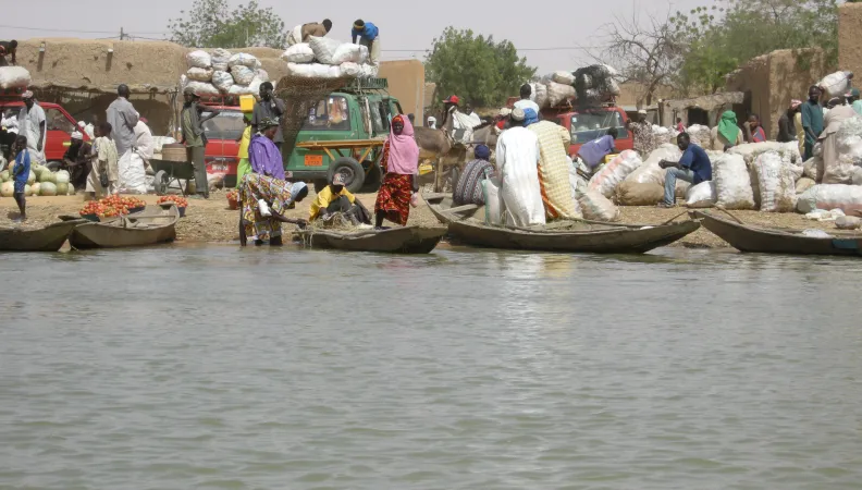
Lake Chad is the second largest wetland area in Africa.
Some three million people from the four neighboring countries (Cameroun, Chad, Niger and Nigeria) make their livelihoods from the resources and services provided by the lake: irrigated agriculture and water recession around the lake, transhumance breeding, fishing, and transport of goods.
The droughts in the 1970s and 1980s and, more recently, in 2008-2010, and the opening of regional roads have promoted trade expansion and led to dual migration dynamics of herders towards the south.
The densities reached on the shores of the lake, of 60 inhabitants/km², are unusual in the Sahel area. This human concentration is likely to crystallize situations of tension, in particular over the issue of resource sharing.
The lake is also subject to strong seasonal and interannual variations.
In 1964, the six States of the lake watershed set up the Lake Chad Basin Commission (LCBC) in order to more effectively manage resources, avoid conflicts of uses and contribute to the economic development of the basin.
Description
The project is based on 3 components:
- Synthesis of knowledge to better assess the human and environmental dynamics of the lake.
- Complement to the water management planning model.
- Support for the introduction of the Water Charter and the strengthening of relations with the other transboundary basin organizations.
Impacts
- Contribute to local social and economic development by improving water, soil and territorial management, and to removing the constraints on irrigated agriculture and fishing.
- Preserve the global environment. Lake Chad is an international RAMSAR site and the Heads of State and Government of LCBC have proposed to make it a world heritage site. The fragile balance of its ecosystem is today threatened by the pressure from the growing population.